


Geosrbija - Digitalna platform
Description of Geosrbija - Digitalna platform
Geosrbija is a digital platform developed by RGA in collaboration with Statens Kartverk, the Norwegian Agency for Cadastre and Cartography. This application integrates various spatial data at the state level, making it an essential tool for public authorities, businesses, and citizens alike. Available for the Android platform, users can download Geosrbija to access a wealth of geographical information.
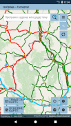
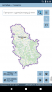
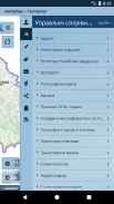
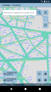
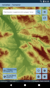
The platform serves as a centralized portal for all spatial data collected by different state institutions, including the Republic Institute for Statistics and the Hydrometeorological Institute. Users can find information related to land, buildings, addresses, protected areas, national parks, and altitude, among other data points. This comprehensive integration allows for a clearer understanding of spatial relationships and data accessibility within the state.
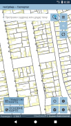
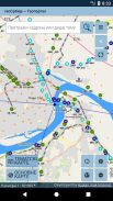
Citizens can utilize the Geosrbija platform to locate their properties and view the current status of their real estate. The application provides satellite and orthophoto imagery, enabling users to visualize their land. This feature is particularly beneficial for individuals seeking to understand zoning regulations or property boundaries. Additionally, users can assess whether their land has been affected by forestry activities or review the status of their properties in official registries.
The platform emphasizes transparency within public authorities by making various datasets readily accessible. This initiative allows citizens to engage more effectively with governmental processes and promotes informed decision-making regarding their properties and local environments. By providing streamlined access to essential spatial data, Geosrbija enhances the relationship between the state and its citizens.
Geosrbija's design focuses on improving the work processes of state institutions, facilitating the collection and updating of vital information. The platform offers tools that can help institutions maintain accurate and current records, which ultimately benefits the public by providing reliable data. This capability is crucial for ensuring that both public authorities and citizens have access to up-to-date information necessary for planning and development.
Users can also explore various layers of data on the platform. For example, they can examine land use classifications, property ownership, and environmental features. This rich dataset allows for a nuanced understanding of the spatial dynamics at play in their local areas. The application’s user-friendly interface simplifies navigation, encouraging users to explore and utilize the data effectively.
Another aspect of the Geosrbija platform is its contribution to national spatial data infrastructure. By integrating multiple datasets, the application supports the development of policies and strategies that rely on accurate spatial information. This integration is vital for effective land management, urban planning, and environmental conservation efforts.
In addition to serving individual users, Geosrbija also supports businesses by providing critical geographical data that can inform investment decisions and operational planning. Companies can assess potential sites for development or expansion, taking into account various factors such as accessibility, zoning laws, and environmental considerations. The availability of such data helps businesses make informed choices that align with local regulations and community needs.
The platform's focus on enhancing collaboration between various governmental agencies is a significant advantage. By centralizing spatial data, Geosrbija fosters an environment where different institutions can share information and work together more efficiently. This collaboration is essential for addressing complex challenges related to urbanization, resource management, and environmental protection.
Geosrbija also includes features that allow users to report discrepancies or issues related to spatial data. This participatory approach encourages citizens to engage actively with the platform and contribute to the accuracy of the information available. By enabling users to provide feedback, the application continually improves its data quality and reliability.
The application is designed to be accessible to a broad audience, from casual users interested in their property to professionals who require detailed spatial analyses. Its intuitive layout ensures that users can navigate the platform with ease, regardless of their technical background. This accessibility is an important aspect of the platform's mission to democratize spatial data.
In summary, Geosrbija is a digital platform that provides comprehensive access to spatial data for public authorities, businesses, and citizens. It integrates diverse datasets, enhances transparency, and supports informed decision-making across various sectors. The application plays a crucial role in fostering collaboration among state institutions and improving the efficiency of data management processes. Users can download Geosrbija to explore and utilize a wealth of geographical information tailored to their needs.
For more information, visit rs.geosrbija.geosrbija.
Geosrbija - Digitalna platform - Version 1.9
(15-04-2020)Geosrbija - Digitalna platform - APK Information
APK Version: 1.9Package: rs.geosrbija.geosrbijaLatest Version of Geosrbija - Digitalna platform
Other versions


Apps in the same category


